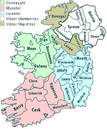
With each province further divided into counties
| Connaught | Leinster | Munster | Ulster |
|
|||
| Leitrim | Dublin | Cork | Armagh |
| Mayo | Kildare | Kerry | Cavan |
| Roscommon | Kilkenny | Limerick | Derry |
| Sligo | Laois | Tipperary | Donegal |
| Longford | Waterford | Down | |
| Louth | Fermanagh | ||
| Monaghan | |||
| Offaly | Tyrone | ||
| Wicklow | |||
| Westmeath | |||
| Wexford |
Map of Ireland showing the location of Counties and Provinces
Local Authorities are also grouped into Regional Authorities on a geographic basis.
| BORDER | Cavan, Donegal, Leitrim, Louth, Monaghan, Sligo |
| DUBLIN | Dublin Corporation, Fingal County Council, Dun Laoghaire-Rathdown County Council, South Dublin County Council |
| MID-EAST | Kildare, Meath, Wicklow |
| MIDLAND | Laois, Longford, Offaly, Westmeath |
| MID-WEST | Clare, Tipperary (North Riding) County Council, Limerick Corporation, Limerick County Council |
| SOUTH EAST | Carlow, Kilkenny, Waterford, Wexford, Tipperary (South Riding) County Council, |
| SOUTH WEST | Cork, Kerry |
| WEST | Galway, Mayo, Roscommon |